 One citizen's view of Longmont, Colorado, USA.
For the first time in nearly six years, the St. Vrain Greenway in Longmont is completely open for it's full length from Golden Ponds (west) to Sandstone Ranch (east).
Over the years, I've expressed my disappointment for the protracted
Greenway closure in the central part of town, to City Council. Reasons I've been given include delays by
BNSF, the initial bids for the Boston Avenue Bridge rebuild were too
high, the pandemic, and delays from the Feds (FEMA and Army Corps of
Engineers). On the other hand, I've praised the work (completed in 2018) the City did for the Greenway rebuild at Sandstone, including the new bridge addition and reroute, and the new routing west of Main by the Dickens Farm Nature Area was well done.
Unfortunately, the full Greenway opening will be short-lived. The section from Boston Avenue to Sunset Street by the Isaak Walton Clubhouse is scheduled to be closed "Spring 2025" (does this mean May or June?) and finished Fall 2026. So, at least another 1.5 years of closure and there is another section of work to be done in the future. Of interest is a bike lane and temporary sidewalk coming this summer along a portion of Boston Avenue for the detour (see below). If you know Boston Avenue, it is poorly drained with sand and large water pools after a rain covering much of its shoulder, and it is also full of debris from industrial traffic. It has never been a usable detour especially for families or anyone on foot. I'm very interested to see if the City comes through on this commitment and maintains the bike lane.

I'll go ahead and post the schedule here and we'll see if the Fall 2026 completion milestone is met:

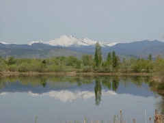
On a Sunday Easter afternoon, I got out on the Greenway before it is closed again.
The previous BNSF railroad bridge was identified as a major pinch point in water flow during the 2013 flood. Here's the new one but did it really take two years to build (2019 to 2021)?

Here's a few pictures of the segment to be closed soon. The dirt surface was temporary after the flood but nobody complains about it.


And looking east from near the Isaak Walton Clubhouse:

Get out there while you can.


